Day 019a: Jenny Was Not a Friend of Mine

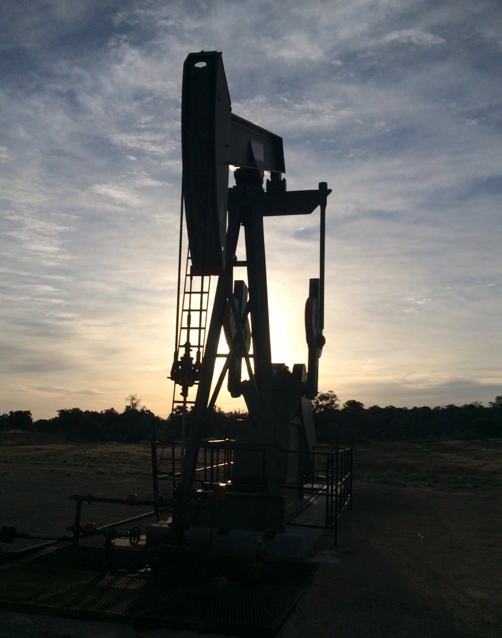
Pic: Oil derrick near Canyonlands NP, UT

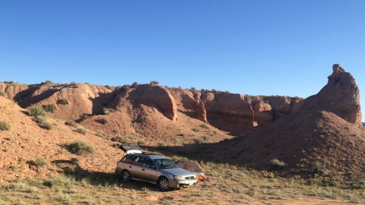
I arrived in the Canyonlands/Arches area after dark and promptly struck out at the developed campgrounds in the area (I thought maaaaybe since it was Sunday night… nope). Camping here was quite restricted due to the sensitive high-desert enviornment and the hordes of visitors, but I had a few weak leads. From UT-313, I took a dirt road to another dirt road to a wide, flat clearing. “Good enough!” I declared.

As I zipped into my sleeping bag shortly after midnight, I noticed the dull hum of an engine running nearby. “Is that asshole RVer gonna run his generator all night?” I wondered before passing out.

I woke just after sunrise and promptly packed up. A review of the map in the clear-headed light of morning revealed that I was probably not supposed to camp here. I do not endorse trespassing or illegal camping; in general, I believe in gathering sufficient information to understand and abide by the law. That said:

1. Leave No Trace.

2. It’s only illegal if you get caught. ; )

I couldn’t resist exploring a little before returning to the highway. Maybe I’d find the noisy RV and a better campsite for next time.

I did find the source of the noise, but it wasn’t a generator. It was an oil derrick — I’d basically spent the night in an oil field. I suspected this activity was… discouraged, so I stayed long enough to snap a few selfies and absconded to Canyonlands.

Day 018b: Where’s Your Headquarters At?

Pic: A slot canyon that is not Headquarters Canyon. Capitol Reef NP, UT

Advice from a ranger in Bryce Canyon had led me to the deserted southern section of the park. After a night in Dirty Undies Gulch, I was ready to see some slot canyons.

First up: Surprise Canyon. I kicked off the two mile round trip by walking around a corner and inadvertently triggering this dude’s “a predator! I will freeze and it will not see me!” subroutine. Surprise!

Day-018b-Black-Tailed-Jackrabbit

Pic: You’re a rabbit in my headlights. Black-tailed Jackrabbit, Surprise Canyon Trail, Capitol Reef NP, UT

At the end of the “official” hike the canyon narrows to a “pouroff”: a fifteen foot-tall block of terraced slickrock. I studied it for a while to convince myself I could get back down if I climbed it, then scrambled over. Beyond the constriction, the canyon opened up to towering vertical cliffs. I wandered as high as I could, had a snack, then returned to discover that the pouroff was way scarier from the top. It was a moment where I felt keenly how alone I was, and how long it would take for help to reach me if I tumbled face-first into the rocks below. Surprise!

It took a few tries (grab a handhold, try to reach the next step, shout “nope! nope! nope!”, repeat) but I made it back to my car and down the road to my next stop, Headquarters Canyon.

The 1.7 mile trail became vague as it meandered through a wash. I poked around trying to find the marked path, ended up on the wrong side of a protuberance visible on the map, reasoned that the twists and turns in the dry creek bed had to go somewhere, and found myself in the not-Headquarters-but-equally-awesome-slot-canyon pictured at the top of this entry.

Capitol Reef was the national park I knew the least about, but as I headed back up Notom-Bullfrog Road toward UT-24, I realized I already wanted to return. One day in this magical section of desert was enough only to whet my appetite for the vertical-walled wonder of Utah slot canyons.

I stopped in Green River for dinner and to figure out where the hell I was going to spend the night. I got a mini-pizza, a cheeseburger, and a little linguistic treat when the teenager behind the counter asked if I wanted my food “to stay or to go”. Utah dialect: Surprise!

Day 018a: Hey Bullfrog

Pic: Caution: road becomes QR code. Notom-Bullfrog Road, Capitol Reef NP, UT

After a full day of driving and exploring, I arrived at my planned camping area well after dark: a swath of BLM land off of amusingly-named Notom-Bullfrog Road, nestled between the two lobes of Capitol Reef NP. I struck out finding a restaurant in Torrey that was open, not a Subway, and not a raucous bar, so my focus was to find somewhere to pitch my tent and to find out how my Jetboil would perform as a heater of canned chili (the answer was “okay, if you use the lowest possible heat setting and stir constantly).

I poked around in the dark, following faint jeep trails into the desert because what could possibly go wrong? Ultimately I found a little hollow with flat ground to sleep on.

I woke early in the unsheltered morning sun and reviewed my surroundings. I’d stumbled onto a perfectly serviceable spot, though after an unsavory discovery nearby (that green/black blob at the edge of the shadows, just to the right of my tent) I was forced to name the area Dirty Undies Gulch:

Day-018a-Dirty-Undies-Gulch

Pic: Dirty Undies Gulch near Capitol Reef NP, UT

Day 017b: Hell’s Backbone

Pic: Waterpocket Fold above Fruita, Capitol Reef NP, UT

Doing no homework meant I enjoyed the sights of the Scenic Drive unspoiled. Towering cliffs of red, white, and chocolatey brown drew climbers to dusty parking lots at the ends of winding flood channels. Abandoned uranium mines dotted the land. And the Gifford Homestead, preserved as an example of Fruita’s previous life as a farming community, sold cups of homemade ice cream complete with little wooden spoons for a buck — the first of my Best $1 Purchases for the trip.

The ranger at the visitor center recommended Fremont Gorge Overlook Trail as a short but worthwhile hike to finish my day. It felt longer than its 4.6 mile 1000′ round trip billing, though it’s possible I passed the named overlook in search of a more overlooky overlook. Regardless, the Gorge presented a nice view of some different geology:

Day-017b-Fremont-Gorge

Pic: Made by water, not plate tectonics. Fremont Gorge Overlook, Capitol Reef NP, UT

Day 017a: Do You *Want* Radioactive Superbats?

Pic: Because that’s how you get radioactive superbats. Oyler uranium mine, Capitol Reef NP, UT

My friend Dave, who lives in Colorado, recommended a breakfast place in confusingly-named Boulder, UT. I still don’t know what “shirred eggs” are but my ignorance didn’t prevent me from devouring them, along with homemade bread with homemade cinnamon butter and homemade jam. I strongly considered a second round of breakfast but decided it was not a good fit for my unemployed dirtbag lifestyle.

UT-12 through Grand Staircase-Escalante National Monument and Dixie NF: best drive of the trip so far. It twists and turns through scorched deserts and cool aspen forests. You can skip Escalante Petrified Forest State Park, though. It’s fine; it has a collection of petrified wood, as advertised. It’s also listed in my notes as “Worst $5 spent (even though it was only $4)”. I guess I was a little let down since it was so soon after my best $5 purchase.

I pulled into Capitol Reef NP having done basically no homework on the area. Jon recommended that I not skip it. The garrulous ranger from Bryce Canyon suggested that I investigate the park’s long thin southern section. Otherwise, I would rely on the knowledgeable men and women of the National Park Service and their glorious infographics.

The view from the parking lot was a promising start:

Day-017a-Visitor-Center-Flag

Pic: The Castle and the Visitor Center. Capitol Reef NP, UT

Day 016b: The Utah Chuckle

Pic: Wall of Windows. Bryce Canyon NP, UT

I tend to overpack a bit due to various factors (ambitious itinerary, traveling solo, use the same 60L pack for half-day hops as for multi-day trips) but I was nonetheless surprised at how little I saw other folks carrying. The rim of Bryce Canyon varies from 8000 to 9000 feet of elevation, which is more than enough altitude to affect a flatlander. Add late spring sun, high desert dryness, and exertion and you have a recipe for a Bad Time.

Hence, I was happy to see a ranger hanging out at a busy and confusing 4-way intersection on the Navajo Loop Trail, dispensing directions and accosting European teenagers: “Where are you headed? I’m a little worried about you since you’re not carrying much — er, any — water.”

During a lull in traffic I greeted the garrulous ranger and learned that dehydration was the most common emergency that park staff handled. I told him about my trip so far and solicited advice about upcoming Capitol Reef. I also told him about the Utah Chuckle, which is a term I invented to describe this common scenario: you are hiking in Utah, agape at the beauty around you. Then, you come around a corner and shake your head and chuckle because you’ve just found something even more indescribably beautiful.

Bryce Canyon gave me quite a few Utah Chuckles.

Day-016b-Hoodoos-Peekaboo-Trail

Pic: Hoodoos from Peekaboo Trail. Bryce Canyon NP, UT

I’d like to give a shout out to the Junior Ranger program in general and the Hike the Hoodoos Challenge in Bryce Canyon specifically. I encountered enthusiastic young participants at every park I visited, interacting with rangers and learning science in the outdoors. Plus, collecting stuff is fun for kids of all beard lengths:

Day-016b-Tyler-Hoodoo-Benchmark-Selfies

Pic: These five selfies earned me an “I Hiked the Hoodoos” badge! Bryce Canyon NP, UT

Day 016a: A Hell of a Place to Lose a Cow

Pic: Ebenezer Bryce’s backyard. Bryce Canyon NP, UT

Bryce Canyon has an unusual layout: civilization is up top; the hikes all go down and then come (steeply) back up. I wanted to see as much of the the 12 mile long, 800′ deep Amphitheater as possible, so I chose the Queens Garden/Peekaboo/Navajo ‘Figure 8’ Combination (what am I, a figure skater?).

Day-016a-Queen-In-Her-Garden

Pic: Unlike Elephant Rock, I needed five minutes, the assistance of three groups of strangers, and exactly the right angle to be able to see this hoodoo as Queen Victoria, wearing robes and a crown, sitting on a throne. Queens Garden, Bryce Canyon NP, UT

Day 015b: You Remind Me of a Man (What Man?)

Pic: Hoodoo? Yeah, you do, you do. Dixie NF, UT

I made an impromptu stop off UT-12 at the Red Canyon Visitor Center in Dixie National Forest. I mostly wanted information about dispersed camping in the area since it is a short drive from Bryce Canyon NP (the ranger suggested an area called Cabin Hollow). I also inquired about a snake discovered in the Moqui Cave parking lot by a woman who seemed surprised that I would run toward a snake to get a better look (the ranger and a field guide agreed that it was a gopher snake).

While I was stopped, I noticed some interesting formations in the nearby hills so I made a sandwich and hiked up Pink Ledges Trail and Hoodoo Trail. In most parts of the world, I’d be content to spend a couple days exploring these features. In southern Utah, this is a quick pit stop between world-famous marvels of geology.

Day 015a: Sir Duke

Pic: The Duke by Garth Chamberlain, “self-taught” wood carver. Moqui Cave, Kanab, UT

On the way up US-89 from Kanab toward Bryce Canyon NP, there is a tourist trap called the Moqui Cave. It turned out to be the best $5 I spent during the entire trip. It’s hard to explain why, except to say that it was hands down the best collection of folk art + fossils + Pittsburgh Steelers memorabilia + archaeological treasures + fluorescent minerals + blacklight paintings I have ever seen.

Day-015a-Fluorescent-Minerals-Velvet-Painting

Pic: Fluorescent minerals and also a velvet painting of a horse. ¯\_(ツ)_/¯ Moqui Cave, Kanab, UT

The young woman who sold me a ticket was also the docent. She explained that original owner Garth Chamberlain, whose family still owns and operates things, purchased the land in 1951 specifically to operate as a roadside attraction. Garth’s career — he played football for the Steelers — and numerous hobbies are reflected in the collection. “For example, he was a self-taught woodcarver,” she said and lead me to The Duke.

“Wow,” I said. Please scroll back up and appreciate it again.

“And he had no formal training?”

“None,” she confirmed.

I’m not here to hate on another person’s hobby. He produced a recognizable carving of John Wayne, something I couldn’t accomplish even with years of tutelage from the world’s greatest wood artists. But you don’t need to tell me that he was self-taught. That is the least necessary disclaimer I’ve heard in at least a week.

Day-015a-George-Washington-By-Garth-Chamberlain

Pic: I am nearly certain that this is George Washington. Wood carving by Grant Chamberlain. Moqui Cave, Kanab, UT

Seriously though, if you have a free hour while traveling between southern Utah’s natural wonders, pull over and spend an hour with Garth’s collection of random objets d’art.

Day 014b: Two and a Half Sheep

Pic: Desert bighorn ewes with a lamb. Zion NP, UT

I think East Zion was my favorite part of the park (other than Angels Landing, but that’s not really fair). Similar architecture and views as the main canyon, 5% of the population, and space to actually get off a ten foot wide paved trail and explore. I wandered up and down the slickrock canyons of Many Pools for hours, marvelling at the bizarre layers of sedimentary rock and startling the frogs and polliwogs hanging out in the puddles where rainwater remained.

After years of hiking through their poop and tracks, I finally saw desert bighorn sheep — two ewes with a lamb. I tried to inch closer for a better photo but, in spite of my stealth and abundant grace, as soon as I stepped into the open they’d had enough of my shenanigans and bolted.